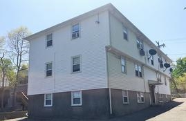
Photos
Request Future Alert
Request Notification
80 Palmer St
Quincy, MA 02169
About 80 Palmer St
80 Palmer St is ready for you to move in. The Adams Shore location has much to offer its residents. This community offers studio to 0 bedroom floorplan options. Ask us about our current pricing. At 80 Palmer St you're home.
Description created using real-time rental pricing and availability.
80 Palmer St is located in the Adams Shore Neighborhood and 02169 Zip code of Quincy, MA.
Property Contact Info
Property Information
- 6 Units
- 2 Stories
- Built in 1950
Map
- Shopping
- Colleges
- Grocery
- Medical
- Parks
- Transportation
- Nearby Properties
Map
Getting Around
Walk Score®
37 / 100
Car-Dependent
Most errands require a car
Bike Score®
31 / 100
Somewhat Bikeable
Minimal bike infrastructure
Transit Score®
31 / 100
Some Transit
A few nearby public transportation options
What Are Walk Score®, Transit Score®, and Bike Score® Ratings?
- Walk Score® measures the walkability of any address.
- Transit Score® measures access to public transit.
- Bike Score® measures the bikeability of any address.
Renters Reviews and Ratings
Nearby Schools
Broad Meadows Middle
- Quincy
- 50 Calvin Road
- 1 min drive/0.5 mi away
- Public School - Grades 6-8 (321 Students)
- In Attendance Zone
Quincy High
- Quincy
- 100 Coddington Street
- 3 min drive/1.3 mi away
- Public School - Grades 9-12 (1495 Students)
- In Attendance Zone
Snug Harbor Community School
- Quincy
- 333 Palmer Street
- 1 min drive/0.6 mi away
- Public School - Grades PK-5 (400 Students)
- In Attendance Zone
About GreatSchools Data on ApartmentHomeLiving.com.
Points of Interest
Time and distance from 80 Palmer St.
Arts Museums and Landmarks | Address | Drive | Distance |
---|---|---|---|
New England Holocaust Memorial | Congress Street | 17 min | 8.1 mi |
Museum of Fine Arts, Boston | 465 Huntington Avenue | 17 min | 8.2 mi |
Boston Public Library | 700 Boylston St. | 17 min | 8.1 mi |
Big Box and Retail | Address | Drive | Distance |
---|---|---|---|
Walgreens | 418 Southern Artery | 3 min | 1.1 mi |
Petsmart | 250 Grossman Dr | 7 min | 3.4 mi |
Autozone | 1404 Dorchester Ave | 11 min | 5.2 mi |
Colleges and Universities | Address | Drive | Distance |
---|---|---|---|
University of Massachusetts, Boston | 100 Morrissey Blvd | 10 min | 5.0 mi |
Curry College | 1071 Blue Hill Ave | 15 min | 7.3 mi |
Tufts University - Boston Campus | 274 Tremont Street | 16 min | 7.7 mi |
Groceries | Address | Drive | Distance |
---|---|---|---|
Stop & Shop | 460 Blue Hill Ave | 13 min | 6.4 mi |
Price Rite | 870 River St | 14 min | 6.8 mi |
Shaw's | 1377 Hyde Park Ave | 16 min | 7.7 mi |
Hospitals | Address | Drive | Distance |
---|---|---|---|
Carney Hospital | 2100 Dorchester Avenue | 10 min | 4.8 mi |
Beth Israel Deaconess Hospital - Milton | 199 Reedsdale Road | 10 min | 5.1 mi |
South Shore Hospital | 55 Fogg Road | 12 min | 5.9 mi |
Military Bases | Address | Drive | Distance |
---|---|---|---|
S Weymouth Naval Air Station Weymouth | 15 min | 7.2 mi | |
S Weymouth Naval Air Station Rockland | 16 min | 7.9 mi | |
Boston Support Center | 18 min | 8.4 mi |
Parks and Recreation | Address | Drive | Distance |
---|---|---|---|
Castle Island | William J Day Blvd | 12 min | 5.8 mi |
Christopher Columbus Waterfront Park | 374 Congress Street, Suite 307 | 15 min | 7.3 mi |
Boston Islands National Park | 408 Atlantic Avenue, Suite 228 | 16 min | 7.7 mi |
80 Palmer St has 3 parks within 7.5 miles, including Castle Island, Christopher Columbus Waterfront Park, and Boston Islands National Park.
Restaurants and Dining | Address | Drive | Distance |
---|---|---|---|
No Name Restaurant | 15 Fish Pier Road | 15 min | 7.1 mi |
Sibling Rivalry | 525 Tremont St. | 16 min | 7.7 mi |
Legal Sea Foods | 255 State Street | 17 min | 8.0 mi |
Shopping Centers | Address | Drive | Distance |
---|---|---|---|
Southern Artery Shopping Center | 495-541 Southern Artery | 3 min | 1.1 mi |
Pilgrim Plaza | 25-35 Scammell St | 4 min | 1.5 mi |
NECB 271 Quincy Ave | 271-281 Quincy Ave | 4 min | 1.4 mi |
80 Palmer St has 3 shopping centers within 1.4 miles.
Transit Stations | Address | Drive | Distance |
---|---|---|---|
Quincy Center Station-Red Line | Saville Row | 4 min | 1.6 mi |
Quincy Center-Greenbush Line | 4 min | 1.6 mi | |
Wollaston Station-Red Line | Newport Ave and Beale St | 5 min | 2.4 mi |
Nearby Neighborhoods
Rental Price Ranges in the Area
Bedroom | Average Rent | Cheapest Rent | Highest Rent |
---|---|---|---|
Quincy Studio Apartments | $2,539 | $1,450 | $6,439 |
Quincy 1 Bedroom Apartments | $2,691 | $1,200 | $6,679 |
Quincy 2 Bedroom Apartments | $3,376 | $1,225 | $9,144 |
Quincy 3 Bedroom Apartments | $3,664 | $875 | $10,000+ |
Quincy 4 Bedroom Apartments | $3,918 | $900 | $10,000+ |
Quincy 5 Bedroom Apartments | $5,667 | $1,000 | $8,500 |
Quincy 6 Bedroom Apartments | $6,173 | $1,175 | $9,175 |
Nearby Apartments
Nearby Homes
Protect yourself from fraud. Avoid Scams and Fraud
Did You Know?
43% of renters tour a property with an agent before signing a lease.