Photos

Request Notification
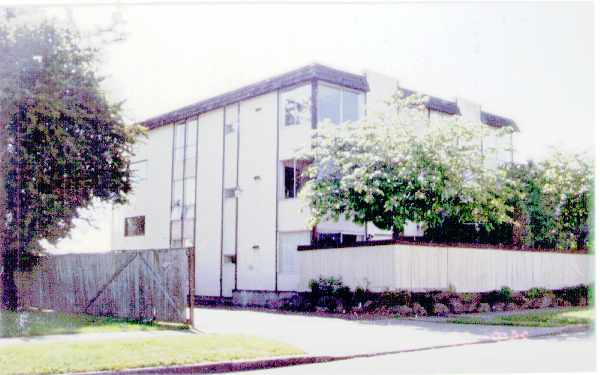
West Seattle Satellite
6314 34th Ave SW
Seattle, WA 98126
Seattle, WA 98126

- 1–2 Bedrooms
- 750–850Square Feet
Property Contact Info
This property currently does not have availability listed on ApartmentHomeLiving.com. Sign up to get notified when it becomes available.
Floorplan Pricing and Availability
New! Interactive Property Map
 ApartmentHomeLiving.com's new Interactive Property Map allows you to see where every available unit is located at this community.Try It Now >
1 Bedroom
1 Bed, 1 bath
1 Bed, 1 Bath, 750 sq ftAvailability Details
Availability Date Unit Sq Ft Unavailable 1 Bed, 1 bath 750 sq ft Model Amenities and Features
Features
- High Speed Internet Access
- Smoke Free
2 Bedrooms
2 Beds, 1 bath
2 Beds, 1 Bath, 850 sq ftAvailability Details
Availability Date Unit Sq Ft Unavailable 2 Beds, 1 bath 850 sq ft Model Amenities and Features
Features
- High Speed Internet Access
- Smoke Free
Price shown is base rent and may not include non-optional fees and utilities. View Fees and Policies for details. Price, availability, fees, and any applicable rent special are subject to change without notice.
Property Information
- 10 Units
- 3 Stories
- Built in 1978
You are leaving ApartmentHomeLiving.com…
Before navigating to this property's external website, would you like to contact them for more information?
Features and Amenities
Interior Features
- Storage Space
- Security System
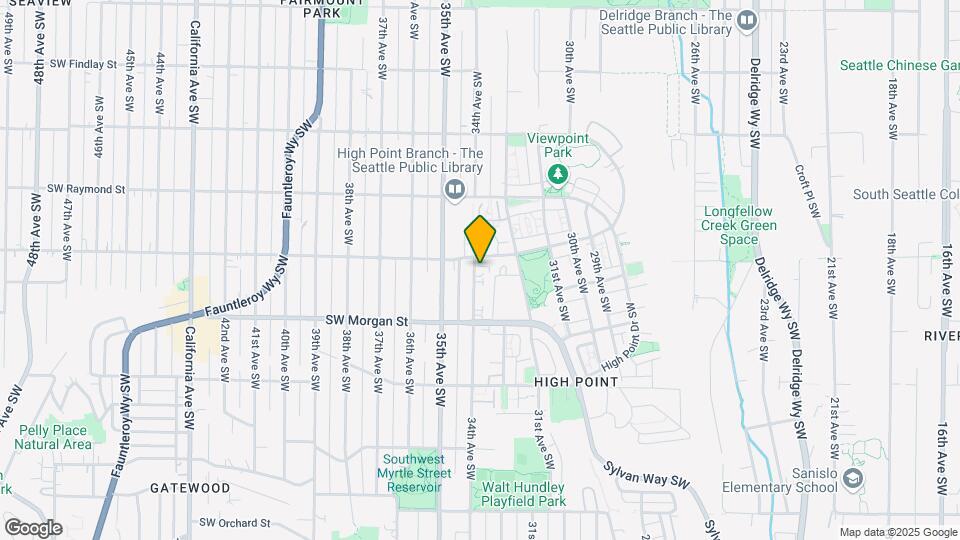
Map
6314 34th Ave SW, Seattle, WA 98126
- Shopping
- Colleges
- Grocery
- Medical
- Transportation
- Nearby Properties
Map
What Are Walk Score®, Transit Score®, and Bike Score® Ratings?
- Walk Score® measures the walkability of any address.
- Transit Score® measures access to public transit.
- Bike Score® measures the bikeability of any address.
Renters Reviews and Ratings
Nearby Schools
Denny Middle School
Seattle Public Schools
2601 SW Kenyon St
Public School - Grades 6-8 (811 Students)
In Attendance Zone3 minute drive / 1.2 miles away
Chief Sealth High School
Seattle Public Schools
2600 SW Thistle
Public School - Grades 9-12 (1289 Students)
In Attendance Zone3 minute drive / 1.2 miles away
West Seattle Elementary School
Seattle Public Schools
6760 34th Avenue Southwest
Public School - Grades PK-5 (381 Students)
In Attendance Zone1 minute drive / 0.3 miles away
Louisa Boren STEM K-8
Seattle Public Schools
5950 Delridge Way Southwest
Public School - Grades PK-8 (483 Students)
In Attendance Zone1 minute drive / 0.6 miles away
School data provided by GreatSchools.
details
The GreatSchools Rating helps parents compare schools within a state based on a variety of school quality indicators and provides a helpful picture of how effectively each school serves all of its students. Ratings are on scale of 1 (below average) and to 10 (above average) and can include test scores, college readiness, academic progress, advanced courses, equity, discipline and attendance data. We also advise parents to visit schools, consider other information on school performance and programs, and consider needs as part of the school selection process.
About GreatSchools Data on ApartmentHomeLiving.com.
About GreatSchools Data on ApartmentHomeLiving.com.
Points of Interest
Time and distance from West Seattle Satellite.
Big Box and Retail
Walgreens
6303 35th Ave SW
1 minute drive / 0.42 miles away
Petco
4724 California Ave SW
3 minute drive / 1.04 miles away
Costco
4401 4th Ave S
4 minute drive / 2.14 miles away
Colleges and Universities
Golden Gate University - Seattle Campus
1424 Fourth Avenue, Suite 410
9 minute drive / 4.44 miles away
Groceries
Thriftway
4201 SW Morgan St
2 minute drive / 0.85 miles away
Whole Foods
39th St
2 minute drive / 0.97 miles away
Safeway
2622 California Ave SW
4 minute drive / 2.21 miles away
Hospitals
Military Bases
Fort Lawton Military Reserve
16 minute drive / 7.78 miles away
Naval Supply Center
17 minute drive / 8.19 miles away
Shopping Centers
West Seattle Satellite has 5 shopping centers within 2.0 miles.
Transit Stations
ST Light Rail & SODO Station (SB)-LINK to Sea-Tac
6 minute drive / 2.86 miles away
ST Light Rail & SODO Station (NB)-LINK to Sea-Tac
6 minute drive / 2.9 miles away
SoDo-Central Link
6 minute drive / 2.94 miles away
Nearby Neighborhoods
Rental Price Ranges in the Area
| Bedroom | Average Rent | Cheapest Rent | Highest Rent |
|---|---|---|---|
| Seattle Studio Apartments | $1,645 | $594 | $4,635 |
| Seattle 1 Bedroom Apartments | $2,268 | $634 | $10,000+ |
| Seattle 2 Bedroom Apartments | $3,136 | $890 | $10,000+ |
| Seattle 3 Bedroom Apartments | $4,300 | $1,099 | $10,000+ |
| Seattle 4 Bedroom Apartments | $2,536 | $1,099 | $10,000+ |
| Seattle 5 Bedroom Apartments | $2,273 | $950 | $10,000+ |
| Seattle 6 Bedroom Apartments | $2,601 | $1,365 | $7,956 |
Nearby Apartments
Nearby Homes
Did You Know?
22% of apartment shoppers plan to spend 4-6 months in their apartment search.